
On a hill above Lough Swilly, at the base of the Inishowen peninsula, there sits a stone fort. The fort is only a hundred and forty years old by some measures – though by others, it could be over two thousand years old. The burial place of gods and the home of kings, it now sits abandoned save for the few visitors who make the trek up the steep hill from the main road. Its name is the Grianan of Aileach – the Sunny Place in the Stones.
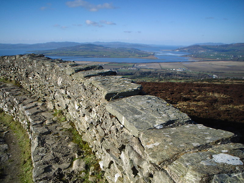
The view from the Grianan.
Photo via Wikimedia Commons
In the second century AD, in the city of Alexandria, in the Roman Province of Egypt, there lived a man called Ptolemy. Ptolemy wrote several books in his lifetime, on astronomy, astrology, music and optics, but the most fascinating of his books is Geographia. This book details the known world as seen from the heart of the Roman empire, and covers about a quarter of the Earth’s surface (which Ptolemy knew), from the Atlantic in the west to China in the east, from Shetland in the north to the eastern coast of Africa in the south. The book included description, coordinates and drawn maps, but the originals of the latter, due to the difficulty in copying them, are lost to time. The book was passed down in the East, through both Islamic and Byzantine scholars, and new editions were produced throughout the Renaissance. The book is invaluable as a historical document, but perhaps the most significant effect of it was that it was the first work to propose the idea of a global coordinate system – the predecessor of the modern longitude and latitude.

A recreation of Ptolemy’s map made in 1467, showing the British Isles.
Photo via Wikimedia Commons.
Ireland appears on Ptolemy’s maps (although not in a very detailed form, as one might expect for somewhere out on the edges of the Empire), and in the north of the country is a point labelled as “Regia” – the city of kings. Of course, nobody is certain where this city of the kings lay, but nineteenth century scholars felt that the strongest candidate was the capital of the northern kingdom of Aileach (which means Stone), whose recorded list of kings stretched back seven hundred years from the twelfth century. Their claimed history stretched back further, to the mythical Tuatha De Danaan. The Tuatha were said to have conquered Ireland from the monstrous Fomorians sometime in the dim and distant past. The Annals of the Four Masters place their time in Ireland between 1500 BC and 1287 BC, though that is assuming that they even existed – they were worshipped as gods by the ancient Celts. Their first king was named Nuada, later Nuada of the Silver Hand after he lost an arm in battle and had it replaced with a working silver prosthesis by the legendary physician Dian Cecht. When he died in battle, he was buried in the great holy site from which the kingdom of Aileach took its name – the Grianan of Aileach, the fort built where a cursed man had buried a god’s murdered son.

An image from a silver cualdron found in Gundestrup, possibly meant to be the Dagda.
Image via Wikimedia commons
The Dagda is an odd figure in Celtic mythology. He is revered as the greatest of the gods – his name, Dag Dia, literally means “The Good God”. He is known as the All-Father, and revered as a king of the Tuatha. On the other hand, he is also portrayed as being fat, oafish, greedy, poorly dressed and lustful beyond belief. His role in some legends is as comic relief, and in others as a power beyond imagining – it is said that to hid the fact that his adulterous affair with the goddess Boand had left her pregnant he literally stopped time until after she had given birth. So it was that when his son Aedh was murdered by a man named Corrgen in a fit of jealous rage (after Corrgen saw his wife glancing at Aedh), so the Dagda pronounced a curse upon him. He must carry Aedh’s body until he saw a stone the exact same size, and then he must bury him there. It is not certain how far Corrgen walked, but eventually he found the stone on the hill and buried Aedh, just before dropping dead. Dagda had his stonemasons build a great wall around the tomb, where he sat and “wept bloody tears”, giving the place the name of Aileac, the Hill of Sighs.
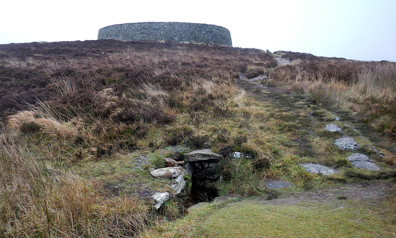
The holy well of St Patrick, on the hill below the Grianan.
Photo via Wikimedia Commons.
Of course, all of this is just myths. Modern archaeologists date the original ringfort on the site back to the Iron Age, and so to 500 BC at the earliest – which means, of course, that it does still predate Ptolemy’s map. In 674 the High King of Ireland, Finsnechta the Festive (of the southern Ui Neill), destroyed the fort. A hundred years later his relatives the northern Ui Neill moved into the site and built themselves a fort there, from which they ruled the kingdom of AiIeach for the next five hundred years. It was burnt by Viking raiders in the tenth century, but rebuilt. Finally, in 1101 the King of Munster, in revenge for the destruction of one of his castles, invaded and demolished the place. He had his men each carry one of the stones from the castle away, so that it could not be rebuilt. It remained the symbolic capital of Aileach until the title of the kingdom fell into disuse in the 13th century, being replaced by the Kingdom of Tir Eoghain (the forerunner of modern Tyrone).

Hugh O’Neill, 2nd Earl of Tyrone, descendant of the Kings of Aileach and last High King of Ireland.
And so the site lay in ruins for centuries, until, as with so many ancient sites. the Victorians rediscovered it. The first was Colonel William Blacker, one of the founding members of the Orange Order and reputed author of the saying “put your trust in God, and keep your powder dry”. He surveyed the site in 1830 and found the ruins, which he described in a letter as a “Palace of the Sun”.
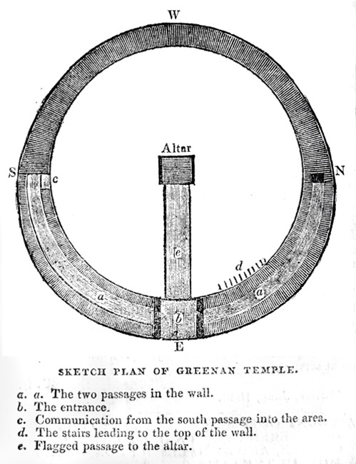
Colonel Blacker’s plan of the Grianan
The second was a man called Michael Harkin, though he wrote under the name of Maghtochair. A teacher and postmaster who lived in Carndonagh, he travelled the countryside in his spare time collecting local folklore which he wrote up for the Derry Journal. His description of the site as it lay in ruins is fascinating, as it sounds more like a passage-tomb rather than a fort – a conclusion he reaches himself, as he does not believe that the Grianan is the mythical Aileach. His logic is somewhat shaky – he does not believe that the Tuatha De Danaan could have used stones for their dwellings as if they had, then the Milesians (a later people, who drove the Tuatha away) would have adopted the custom. He declares that the nearby Burt Castle (built in the 16th century) is more likely to be the site of the old capital – an interesting theory, though sadly not one that any evidence supports. (An archaeologist friend of mine who visited the Grianan in 2009 would agree with him, though – well experienced with Norman castles, he declared the position of the Grianan “indefensible”.)

Dr Walter Bernard
What makes Maghtochair’s description all the more valuable is what the third Victorian did. Dr Walter Bernard visited the site in 1861, drawn by Blacker and Maghtochair’s descriptions. What he found did not quite match his expectations – decades of sight-seers and amateur archaeologists searching for buried treasure had severely damaged the site, and ten years later he found it in even worse shape. He determined to restore it, and over the course of five years convinced the local farmers to help him do so. They were all experts in the art of dry masonry – that peculiar Irish art of constructing stone walls without the aid of cement or mortar – and work on the Grianan became almost a masterwork for these artisans. To complete the work Dr Bernard had to bring almost a thousand stones from the surrounding land, lending some credence to the tale of the Munster men bearing off the stones. Some funding was given by local worthy policies, and some came from Dr Bernard’s own pocket. In 1878 he declared their work complete and presented his results to the Royal Irish Academy, asserting the next year on inspecting the structure that it would last “for ages”.

Dr Bernard’s plans of the restored Grianan
The Grianan of Aileach still stands today, looking down into the valley. Even if just for the view it is worth a visit. The years have not been kind to the old fort – wind tore down one wall, vandals another, and while repairs have been done, half-hearted conservation efforts more concerned with securing the walls in place than preserving their integrity means that little of the dry stone masonry survives. Still, the place has a stark beauty. Some days the air is solid with big black flies, some days the wind and the rain tear right through your body as the view tears through your soul, and some days the sun breaks through the clouds and falls on the stones, where a god once sat and wept.


Pingback: Today’s Scribbling: The Sunny Place in the Stones – Daily Scribbling